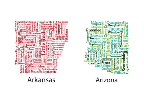
Evaluating the States of Arkansas and Arizona Vector Typographic Maps
In the realm of regional graphic design, finding assets that balance geographic accuracy with aesthetic appeal is a persistent challenge. The States of Arkansas and Arizona Vector collection addresses this specific niche by offering typographic maps where state silhouettes are constructed entirely from the names of their respective counties and cities. Rather than relying on traditional border lines or topographical shading, these designs utilize font size, weight, and color variation to create a recognizable word-cloud effect. For designers, educators, and marketers focused on these specific regions, this resource represents a distinct departure from generic clip art, providing a sophisticated visual tool that communicates local identity through data-driven typography.
Typographic Construction and Visual Hierarchy
The primary value proposition of this vector set lies in its execution of the word-cloud concept. Creating a legible map out of text requires more than simply placing labels within a boundary; it demands a rigorous adherence to visual hierarchy. In these files, major population centers like Phoenix, Tucson, Little Rock, and Fayetteville naturally dominate the composition due to larger font sizes, while smaller municipalities and rural counties fill the negative space with finer type. This arrangement serves a dual purpose: it maintains the integrity of the state’s outline while simultaneously conveying demographic or geographic importance.
From a production standpoint, the readability of the text is crucial. Many typographic maps fail because the text becomes an abstract texture rather than legible information. The States of Arkansas and Arizona Vector files appear optimized for clarity, ensuring that even at medium scales, individual city and county names remain distinguishable. The color differentiation further aids in parsing the dense information, allowing viewers to separate adjacent jurisdictions visually without the need for harsh stroke lines. This makes the maps particularly effective for infographics, educational posters, and editorial layouts where context matters as much as aesthetics.
Technical Specifications and Workflow Integration
Professional designers require assets that integrate seamlessly into existing workflows without necessitating extensive cleanup. This package includes both AI (Adobe Illustrator) and PDF formats, compressed into a single high-resolution ZIP archive. The inclusion of native AI files is the most significant technical advantage here. Unlike rasterized images or flattened PDFs, the vector format allows for complete non-destructive editing.
- Color Customization: Users can globally adjust color palettes to match brand guidelines or print specifications using global swatches or recolor artwork tools.
- Typography Editing: Text remains live, meaning fonts can be changed, tracked, or resized if specific styling requirements dictate a different aesthetic.
- Scalability: As true vectors, these maps can be scaled from business card size to billboard dimensions without pixelation or loss of edge definition.
- Layer Management: Properly organized layers allow for quick isolation of specific elements, such as separating the background shape from the text overlay.
The PDF option serves as a reliable fallback for users who may not have access to Adobe Illustrator but still require high-quality print output. PDFs preserve the vector data, making them suitable for professional printing services that accept standard portable formats. However, for maximum flexibility, the AI source files are the intended primary asset for serious creative work.
Practical Applications Across Industries
The utility of the States of Arkansas and Arizona Vector extends across several professional verticals. Understanding where these assets perform best helps potential users determine ROI.
Regional Marketing and Tourism
For destination marketing organizations (DMOs), chambers of commerce, and real estate agencies, generic state outlines often feel impersonal. A typographic map inherently tells a story of community and breadth. Real estate professionals covering multi-county areas can use these maps to visualize service territories in listing presentations or office branding. Tourism boards may find the word-cloud style effective for "road trip" campaigns or visitor guides, as the density of town names suggests exploration and discovery.
Education and Publishing
Educators and textbook publishers benefit from the dual-function nature of these graphics. They serve as both a geography reference and a literacy tool. In classroom settings, the varying font sizes provide a built-in lesson on population density and urbanization. For academic publishers focusing on Southwestern or Southern U.S. demographics, these vectors offer a cleaner, more modern alternative to dated political maps, suitable for journal covers, slide decks, and supplementary materials.
Corporate and Government Reporting
Annual reports, grant proposals, and public health communications often require regional visualization. The professional tone of these typographic maps avoids the cartoonish quality sometimes associated with illustrative cartography. When presenting data regarding statewide initiatives in Arkansas or Arizona, these maps provide a neutral yet engaging backdrop that reinforces the scope of coverage without distracting from statistical overlays.
Quality Assessment and Design Considerations
When evaluating any pre-made vector asset, one must assess the balance between convenience and customization. The States of Arkansas and Arizona Vector scores well on immediate usability. The silhouettes are accurate, and the placement of text respects actual geographic positioning—a common failure point in cheaper alternatives where towns are placed arbitrarily to fit the shape. Here, the spatial relationship between cities appears grounded in reality, which is essential for maintaining credibility with local audiences who will immediately spot geographical errors.
However, users should approach this resource with realistic expectations regarding customization depth. While the text is editable, significantly altering the layout (e.g., adding new suburbs or removing depopulated areas) requires manual typesetting and spatial adjustment. Word clouds are delicate ecosystems; moving one large city name often necessitates reflowing dozens of smaller surrounding names to prevent overlap or gaps. Therefore, this asset is best suited for projects where the current list of cities and counties is sufficient, or where only minor color and font tweaks are needed.
Additionally, font licensing warrants attention. The AI files will contain specific typefaces used to create the original design. If you do not own licenses for those exact fonts, opening the file may result in font substitution warnings. Professional users should either acquire the necessary font licenses or plan to replace the typeface entirely upon opening the file. This is standard practice for vector assets but remains a critical workflow consideration to avoid unexpected rendering issues.
Audience Fit and Value Proposition
This vector pack is specifically valuable for professionals who operate at the intersection of regional focus and high-design standards. It is less suitable for national campaigns where Arkansas and Arizona are merely two of fifty states in a broader dataset; in such cases, simplified icons are usually preferable. However, for dedicated regional projects, the level of detail provided justifies the investment over free alternatives.
Freelancers and agency designers working with clients in these states will likely see the highest time-savings. Constructing a typographic map from scratch involves gathering municipal data, verifying spellings, sourcing appropriate fonts, and spending hours on manual kerning and placement. By starting with the States of Arkansas and Arizona Vector, designers bypass the most tedious phases of production, allowing them to focus on integration and messaging.
For small business owners and non-designers, the learning curve for editing AI files may be steep. Those without vector software experience might find the PDF version useful for basic placement but limited for customization. In such scenarios, hiring a freelancer to adapt the source file may be more cost-effective than attempting to learn Illustrator solely for this task. Conversely, for experienced creatives, the clean structure and high resolution of these files make them a dependable component in a regional design toolkit.
Final Verdict on Usability
The States of Arkansas and Arizona Vector collection succeeds because it treats typography as a structural element rather than mere decoration. It bridges the gap between informational cartography and artistic expression, delivering a product that is both visually striking and functionally robust. The provision of print-ready, high-resolution source files ensures longevity and adaptability across various media formats.
While no pre-made asset can perfectly anticipate every project's unique needs, this set provides a solid foundation that significantly reduces production time for regional content. Its strengths lie in accurate geographic representation, clear visual hierarchy, and professional-grade file organization. For marketers, educators, and designers tasked with visualizing these specific states, it offers a practical solution that elevates the perceived quality of regional communications. Users who understand the parameters of vector editing and respect the complexity of typographic layouts will find this resource to be a worthwhile addition to their asset library, capable of delivering polished results across digital and print applications.